


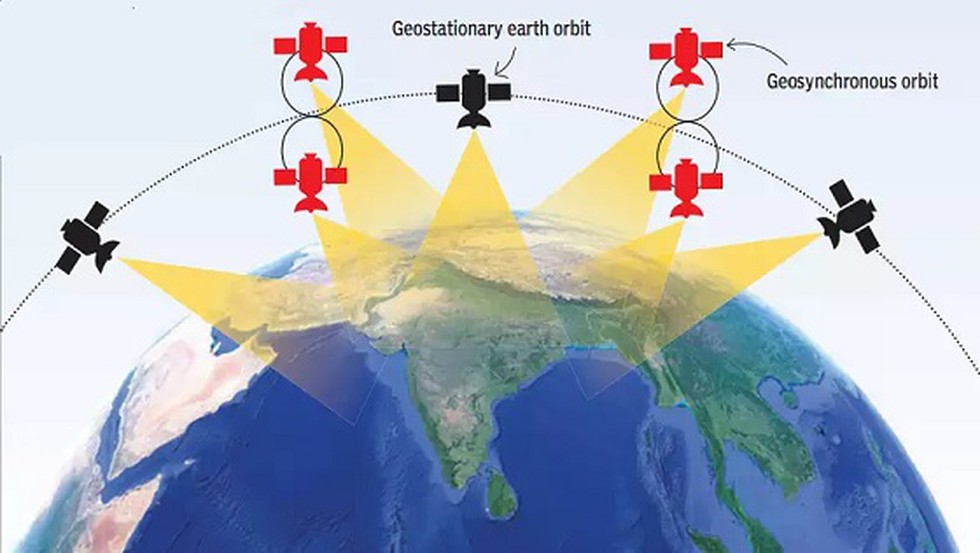
Nowadays, Google's monopoly (Google map) in navigation systems has been somewhat reduced by India's indigenous navigation system NAVIC. It is India's navigation system made with indigenous technology. NAVIC is built to provide accurate and perfect map information. It mainly works to provide mapping services in India's interior and surrounding areas, which works on the basis of information provided by satellites. This navigation system works in collaboration with 7 artificial satellites. 3 Geostationary and 4 Geosynchronous orbits of this artificial satellite. According to many, the information provided by NAVIC Maps of India is more accurate than Google Maps.
Table of Contents
History of NAVIC
NAVIC Navigation System (IRNSS) is India's navigation system developed to provide reliable and accurate navigation services to users of the country and surrounding regions. The system has undergone significant development since its inception over the past few decades. NAVIC navigation has gone through many ups and downs since its inception.
At present NAVIC is operated by a constellation of navigation satellites. But it was not like that from the beginning. When the NAVIC navigation system was conceived in the 1990s, India needed to depend on foreign navigation systems. India's dependence on foreign navigation systems becomes a concern for the country's strategic interests and internal security.
Then the Indian space research organization (ISRO) started developing its navigation system and the first satellite was launched in 2013. Since then the NAVIC navigation system has become capable of providing more complete and accurate maps over time. Which is now the world's most famous navigation information company, leaving behind the top position.
Purpose of NAVIC
As mentioned earlier NAVIC navigation system is based on India's technology. From this, it can be easily assumed that India is not dependent on any other country for its navigation satellites. One of NAVIC's primary goals is to provide reliable and accurate navigation services to users in India and surrounding regions, including parts of Asia, the Middle East, and Africa. Today, NAVIC maps provide users with a wealth of information including real-time traffic updates, weather information, and more.
Apart from this, the data provided by NAVIC will provide additional benefits in the fields of defense, agriculture, meteorology, and space exploration of the country.
NAVIC Map Features
Apart from being India's navigation system, NAVIC differs from any other navigation system in several aspects. They are as follows -
1) Determination of location –
NAVIC is capable of providing accurate map location information from other navigation systems. Also, the NAVIC navigation system can navigate to the desired destination.
2) Coverage –
Serving India and its surrounding areas to be India's navigation system. Even in areas of India where all other navigation systems cannot work.
3) Real-time updates -
This Indian technology NAVIC provides real-time data on traffic, road location, etc. on the map. So that users can make accurate and timely decisions while navigating.
4) Usability in multiple languages -
NAVIC can be used in multiple languages. Compatible users will have the opportunity to operate in multiple languages in addition to English.
5) Use without Internet -
It is possible to use NAVIC offline or without the internet. There are many areas of India where the internet is not reached or have limited internet access, and the users of those areas are particularly benefited.
NAVIC map facility
NAVIC plays an important role in India's space exploration, including the defense sector, besides facilitating the navigation of India and its surrounding communities.
1) Accuracy -
NAVIC is much more accurate than other navigations. Especially in remote or hostile environments, NAVIC is capable of providing accurate information on maps.
2) Reliability -
First of all, NAVIC is said to be India's own proprietary and developed technology. NAVIC is not controlled under the whims and caprices of any foreign power.
3) Encouragement to other industries -
NAVIC navigation system boosts defense, aerospace, agriculture, and technology industries in India. Which in turn boosts new jobs and innovation.
4) Cost-effective -
NAVIC maps are developed by the Indian Space Research Organization (ISRO). Many people know that ISRO manufactures its rockets and satellites very cheaply. Naturally, NAVIC Map being an ISRO project is much cheaper than other mapping systems. NAVIC maps are a cost-effective solution for navigation in India, reducing the need for expensive foreign navigation systems.
Conclusion
NAVIC is a valuable navigation system designed to provide accurate and reliable navigation information to users in India and surrounding regions. Its features and benefits have made NAVIC Maps the most reliable navigation system in India. It is also an important tool in India, which is more accurate, reliable, and cost-effective than other navigation systems.


